


【Technical Analysis】From Military Use to Public Safety, Nearshore Radar Unlocks a New Dimension in Ocean Protection
Release time:
2025-08-02
In today's booming global ocean economy, nearshore security radars are breaking the boundaries of traditional military applications, becoming the "eyes of wisdom" that protect marine ecosystems and ensure public safety. This monitoring system, integrating cutting-edge technologies such as high-frequency ground waves, phased arrays, and synthetic aperture, is building a three-dimensional marine governance network in the fields of maritime management, environmental monitoring, and fisheries protection with its all-weather, high-precision characteristics.
The "three-dimensional defense line" of public safety

The Yangtze River waterway is a golden link connecting the east and west, and it is also an area with frequent meteorological disasters such as rainstorms and fog. In the Chongqing section of the Yangtze River Golden Waterway, the Chongqing Meteorological Department has densely deployed 75 meteorological observation stations in disaster-prone areas and built new-generation weather radar and X-band phased array weather radar equipment to ensure that the distance between observation stations in disaster-prone areas is no more than 10 kilometers.
During the 2024 National Day holiday, in the face of a typhoon with winds of 5-8, the system completed the entire closed-loop process from warning issuance to ship response within 15 minutes, ensuring that the work of securing cruise ships was carried out in a timely manner, effectively ensuring the safety of 137 tourists, becoming an "invisible shield" that protects lives.

In Weizhou Island, Beihai, the typhoon warning system built by the linkage of radar and satellite cloud charts activated an emergency response 48 hours before Typhoon "韦帕" (Weipa) struck in 2025, and safely evacuated 27,000 tourists in just 24 hours. This "radar monitoring + meteorological modeling" model has reduced the disaster warning response time in coastal tourist areas to within 15 minutes.
The "invisible guardian" of coastal safety
In 2024, to address the pain point of supervising "three-no" speedboats (minimum reflection area of only 0.1m²), the Lianyun Port Detachment launched the construction of the "Lianyun Port Fisheries Administration Comprehensive Management Platform" in October of the same year.
Within two months, 5 radars, 11 photoelectric devices, and 1 unmanned aerial vehicle base station were deployed. Through the strengthening of small target radar technology and the use of high-frequency ground wave technology to break through line-of-sight limitations, it can detect moving targets above 1 meter in height and maintain 95% recognition accuracy even in heavy rain.
In 2024, the system transferred more than 40 clues, assisting in solving more than 20 cases. In 2025, the clue submission efficiency increased by 50%, effectively improving the efficiency of law enforcement against "three-no" speedboats, forming a digital law enforcement closed loop of "data portrait—scientific judgment—precise strike".
In Cangnan, Wenzhou, the combination of radar and high-altitude video surveillance has achieved seamless coverage of a 2740-square-kilometer sea area, and the supervision efficiency of 33 law enforcement officers is equivalent to that of 300 people under the traditional model.
In the field of anti-smuggling, the coordinated operations of radar and unmanned aerial vehicles have demonstrated amazing efficiency. Guangdong Maritime Police used the rapid scanning capability of phased array radar to build a 50-kilometer radius early warning circle in the Zhujiang River Estuary. In 2024, through the closed-loop process of "radar locking - UAV verification - speedboat interception", 127 smuggling cases were detected, with a value exceeding 300 million yuan. The application of this technology combination has transformed the traditional "searching for a needle in a haystack" model that relies on manual patrols into precise strikes.
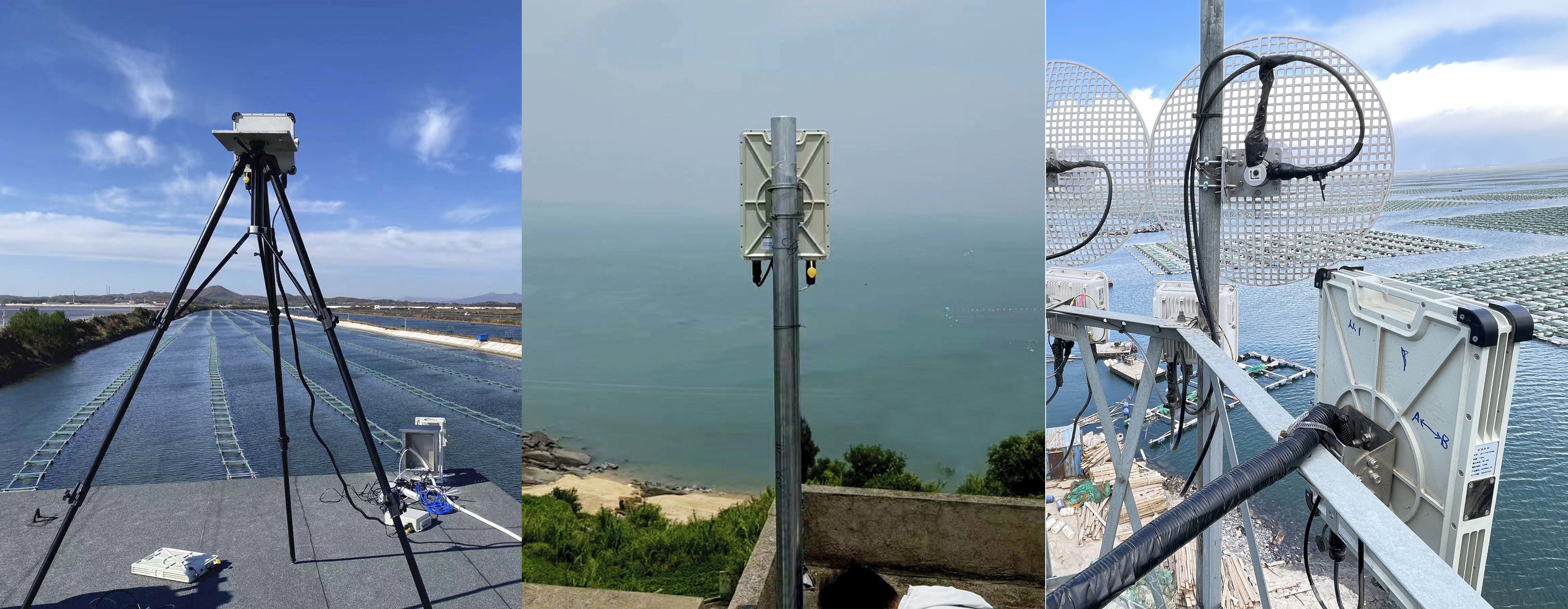
Real scene picture of Lekeda XW/SR237 series products
Wuhan Lekeda Technology Co., Ltd. Independently developed XW/SR237 series nearshore security radar It can cover ranges of 1.2km, 3km, 5km, and 8km respectively according to different scene needs. For fast-moving targets such as large aircraft and speedboats, the high data refresh rate can continuously and stably track.
Suitable for substation, detention center, oil pipeline and other infrastructure security, as well as airport perimeter, railway line security and other scenarios.
From preventing illegal entry and smuggling activities to responding to maritime emergencies, nearshore radar is the "invisible guardian" of maintaining coastal security. It can monitor specific sea areas around the clock, promptly detect abnormal vessels and suspicious activities, and synchronize information to border defense and maritime departments to form a rapid response mechanism.
From intelligent scheduling of the Yangtze River waterway to typhoon defense in Beihai, nearshore security radar is reconstructing the underlying logic of marine governance through technological innovation.
This transformation from "military-only" to "public benefit" not only demonstrates the power of technology for good, but also indicates that human understanding and management of the ocean is moving towards a new era of precision and intelligence.


Address:8th Floor, Building 20, Guanggu New Power, East Lake High-Tech Development Zone, Wuhan, 430205.
Telephone:+86 13343423376 / +86-027-65520251
E-mail:lkd@radardo.com


SAF Coolest v1.3.1.2 设置面板 ADSSX-AONN-OSSVE-ZEZ
无数据提示
Sorry, the current column is being updated, please look forward to it!
You can view other columns or returnHome Page