


XW/SR226-7000XB Xuanwu Series - Low Altitude Security Radar
Drone: ≥7.0km (RCS=0.01m²) Operating Mode: Phased array system (azimuth mechanical scan + elevation electronic scan) Product Composition: Consists of 2 radar arrays and 1 turntable Application Field: Mainly used for detecting, warning, and target indication of low-altitude drones and aircraft in key areas such as borders, airports, and bases. It can accurately provide target azimuth, distance, altitude, speed, and other trajectory information.
Classification:
- Product Description
- Product Characteristics
- Product Index
- Product Size
- Detection Range
-
- Commodity name: XW/SR226-7000XB Xuanwu Series - Low Altitude Security Radar
- Frequency Band: X-band
- Work system: Phased array system (azimuth mechanical scanning + elevation phase scanning)
- Working frequency band: X-band
- Range: >=10.0km
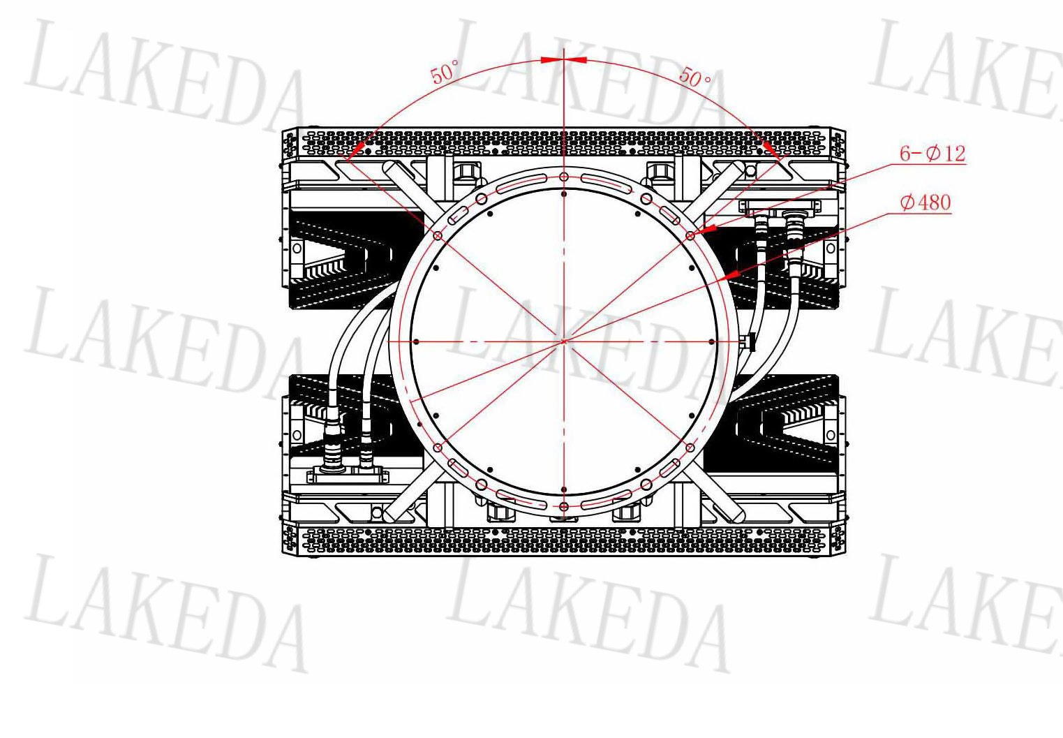
- Azimuth coverage: ≥360°
- Elevation coverage: ≥40°
- Detection speed: 1.0m/s to 75m/s
- Azimuth accuracy: ≤ 0.4°
- Pitch accuracy: ≤ 0.5°
- Distance accuracy: ≤ 0.5m/s
- Data Rate: >=1Hz (Antenna rotation speed: >=30rpm)
- Data Interface: RJ45, UDP protocol 100Mbps Ethernet
- Power Input: ≤1000W (Power Consumption) AC200V-AC240V
- Working temperature: -40℃ to +55℃
- Weight: ≤135kg
Drone: ≥7.0km (RCS=0.01m²) Operating Mode: Phased array system (azimuth mechanical scan + elevation electronic scan) Product Composition: Consists of 2 radar arrays and 1 turntable Application Field: Mainly used for detecting, warning, and target indication of low-altitude drones and aircraft in key areas such as borders, airports, and bases. It can accurately provide target azimuth, distance, altitude, speed, and other trajectory information.
The XW/SR226-7000XB is an advanced micro/small civilian drone detection system, suitable for security protection in key areas such as borders, airports, and bases.
It consists of two radar arrays and one mechanical turntable as its main components.
The radar arrays are the core of the system, responsible for detecting and tracking drones;
The mechanical turntable ensures flexible rotation of the radar, enabling all-around monitoring.
The system can obtain real-time trajectory information of drones such as azimuth, distance, altitude, and speed, providing accurate data for alerting and target indication, effectively ensuring the security of key areas. It can accurately provide the target's azimuth, distance, altitude, and speed trajectory information.
-
High real-time and high precision
Real-time tracking, high target accuracy, continuous trajectory , data update rate reaches >= 1Hz (Antenna rotation speed: >= 30rpm )
Strong environmental adaptability
Adapted to harsh environments such as night, rain, snow, fog, and dust
Phased array system
Adopts advanced active phased array system to enhance radar detection performance and can output three-coordinate target information
Omnidirectional detection
360° omnidirectional detection, real-time target tracking
Application scenarios
Suitable for detection, warning, and target indication of low-altitude drones and aircraft in key areas such as borders, airports, and military bases
-
Operating System
Phased Array System ( Azimuth Mechanical Scanning + Elevation Phase Scanning)
Operating Mode
Pulse Doppler
Operating Frequency Band
X Band
Instrument Range
≥ 10.0 km
Maximum Detection Distance
≥ 7.0 km ( RCS=0.01 ㎡);
Minimum Detection Distance
≤ 150m
Detection Range
Azimuth Coverage : ≥ 360 °
Elevation Coverage : ≥ 40 °
Detection Speed
1.0m/s ~ 75m/s
Measurement Accuracy
Distance Accuracy : ≤ 10m
Azimuth Accuracy : ≤ 0.4 °
Elevation Accuracy : ≤ 0.5 °
Speed Accuracy: ≤ 0.5m/s
Data Update Rate
≥ 1 Hz (Antenna Rotation Speed: ≥ 30rpm )
Target Capacity
≥ 200 Batch
Data Interface
RJ45, UDP Protocol 100 Mbps Ethernet
Power Supply and Consumption
Power Consumption: ≤ 1000W
Operating Voltage: AC 200 V -AC240 V
Operating Environment
Operating Temperature: -40 ℃~ +55 ℃
Storage Temperature: -45 ℃~ +65 ℃
Dust and Water Resistance Rating: IP66
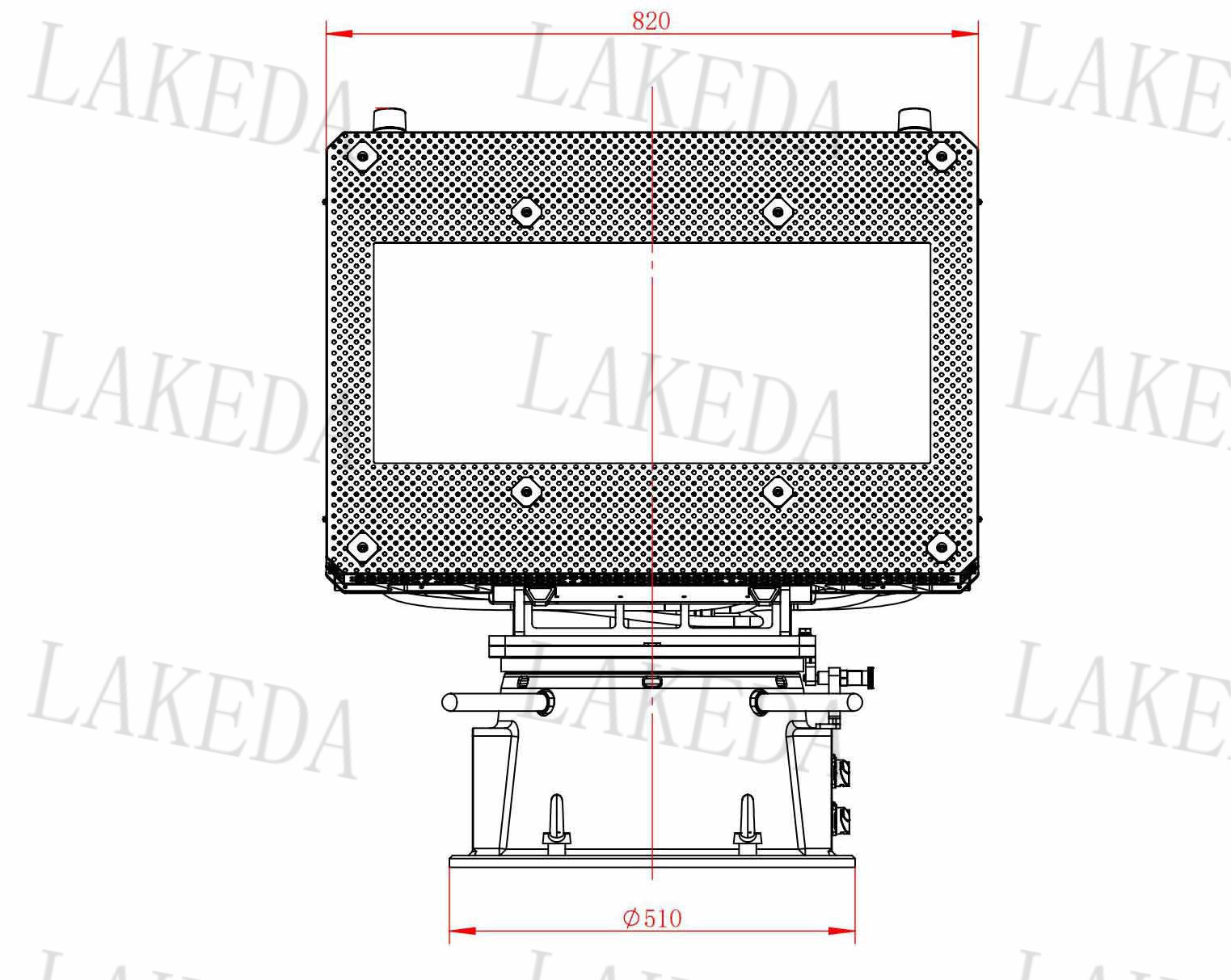
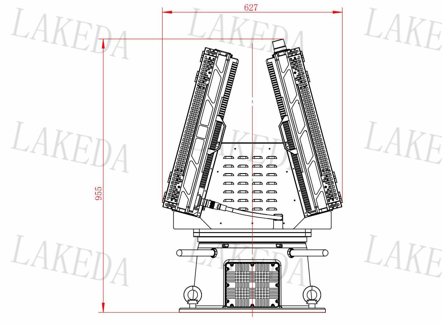
Dimensions
820mm × 360 mm × H925mm
Weight
≤ 135 kg
Note: Operating environment tests refer to the relevant parts of "GJB150A-2009 Military Equipment Laboratory Environmental Test Methods."
-
-
Detection Range
Drone (RCS=0.01m²)
≥7.0km
Key words:
RELATED
Related Products
RELATED
Related Solutions

Solution
Thunderbolt All-in-One Machine


RELATED
Related Application Cases
Product Consulting

Address:8th Floor, Building 20, Guanggu New Power, East Lake High-Tech Development Zone, Wuhan, 430205.
Telephone:+86 13343423376 / +86-027-65520251
E-mail:lkd@radardo.com


SAF Coolest v1.3.1.2 设置面板 ADSSX-AONN-OSSVE-ZEZ
无数据提示
Sorry, the current column is being updated, please look forward to it!
You can view other columns or returnHome Page