


XW/SR226-6000XP Xuanwu Series - Low Altitude Security Radar
Pedestrian: 8.0km Vehicle: 10.0km Drone: 5.0km Ship: 15km Operating system: Phased array system (azimuth scanning + elevation phase scanning) / pulse Doppler Product composition: Consists of 1 radar array, 1 mechanical turntable, and 1 power adapter Application fields: Mainly used for detection, warning, and target indication of micro/small civilian drones in key areas such as borders, perimeters, airports, and bases. It can accurately provide target azimuth, distance, altitude, speed, and other trajectory information.
4000m 删
Classification:
- Product Description
- Product Characteristics
- Product Index
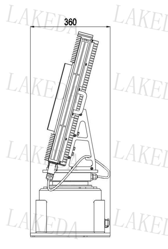
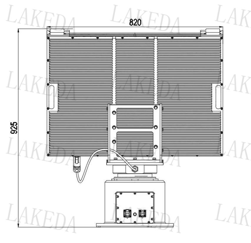
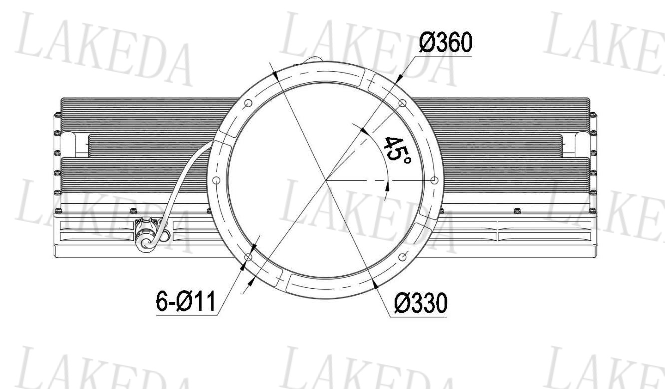
- Product Size
- Detection Range
-
- Commodity name: XW/SR226-6000XP Xuanwu Series - Low Altitude Security Radar
- Frequency Band: X-band
- Pedestrian: 4000m 删
- Vehicle:
- Work system: Phased array system (azimuth scanning + elevation phase scanning) / pulse Doppler
- Working frequency band: X-band
- Range: 6km
- Effective detection power: 100m~5.0km (RCS=0.01m², DJI Phantom 4)
- Azimuth coverage: 360°
- Elevation coverage: 40°
- Detection speed: 0.5m/s to 75m/s
- Azimuth accuracy: ≤0.4°
- Pitch accuracy: ≤0.5°
- Distance accuracy: ≤10m
- Data Rate: ≥0.2Hz
- Data Interface: RJ45/1-port 100Mbps Ethernet
- Power Input: ≤400W (Power Consumption) AC200-AC240 (Input)
- Working temperature: -40℃ to +55℃
- Weight: ≤77kg (complete machine)
Pedestrian: 8.0km Vehicle: 10.0km Drone: 5.0km Ship: 15km Operating system: Phased array system (azimuth scanning + elevation phase scanning) / pulse Doppler Product composition: Consists of 1 radar array, 1 mechanical turntable, and 1 power adapter Application fields: Mainly used for detection, warning, and target indication of micro/small civilian drones in key areas such as borders, perimeters, airports, and bases. It can accurately provide target azimuth, distance, altitude, speed, and other trajectory information.
The XW/SR226-6000XP radar mainly consists of a radar array and a turntable,
used for detection, warning, and target indication of low-altitude drones and aircraft in key areas such as borders, airports, and bases,
capable of accurately providing target azimuth, distance, altitude, and speed trajectory information, and also able to detect small drones and birds flying in the air,
and can be integrated into combat systems such as photoelectric radar detection systems and laser countermeasure systems 。
-
High real-time and high precision
Able to maintain high-precision tracking for long-distance detection targets, providing effective judgment basis for border defense soldiers
Strong environmental adaptability
Capable of all-weather and all-time operation, suitable for harsh environments such as night, rain, snow, fog, and dust
High flexibility
Long-distance target detection, easy to set up
DBF technology
DBF technology's multi-beam transmission can improve anti-interference capability
Phased array system
Adopts advanced active phased array system to enhance radar detection performance and can output three-coordinate target information
High cost performance
Through continuous refinement of the product, it achieves a perfect combination of reliability, usability, and economy while ensuring detection effectiveness
-
Operating System
Phased Array System (Azimuth Scan + Elevation Phase Scan) / Pulse Doppler
Operating Frequency Band
X Band
Range
6km
Effective Detection Capability
100m~5.0km (RCS=0.01m 2, DJI Phantom 4)
Azimuth Coverage
360°
Elevation Coverage
40°
Detection Speed
0.5m/s~75m/s
Azimuth Accuracy
≤0.4°
Elevation Accuracy
≤0.5°
Distance Accuracy
≤10m
Speed Accuracy
≤0.5m/s
Data Rate
≥0.2Hz
Data Interface
RJ45 / 1 Port 100Mbps Ethernet
Power Input
≤400W (Power Consumption) AC200-AC240 (Input)
Operating Temperature
-40℃~+55℃
Weight
≤77kg (Whole Unit)
-
-
Detection Distance
Person
≥8.0km
Vehicle
≥10.0km
Ship
≥15.0km
Drone
≥5.0km
Key words:
RELATED
Related Products
RELATED
Related Solutions

Solution
Thunderbolt All-in-One Machine


RELATED
Related Application Cases
Product Consulting

Address:8th Floor, Building 20, Guanggu New Power, East Lake High-Tech Development Zone, Wuhan, 430205.
Telephone:+86 13343423376 / +86-027-65520251
E-mail:lkd@radardo.com


SAF Coolest v1.3.1.2 设置面板 ADSSX-AONN-OSSVE-ZEZ
无数据提示
Sorry, the current column is being updated, please look forward to it!
You can view other columns or returnHome Page