


XW/SR226-5000SA Xuanwu Series - Low Altitude Security Radar
Drone: ≥5.0km (RCS=0.01m²) ≥25km (RCS=10m²) Operating system: Phased array system (three coordinates) / Pulse Doppler Product composition: Consists of 1 radar array, 1 mechanical turntable, and 1 power adapter Application field: Mainly used for detection, alerting, and target indication of micro/small civilian drones in key areas such as prisons, exhibitions, and bases. It can accurately provide target azimuth, distance, altitude, speed, and other track information.
Classification:
- Product Description
- Product Characteristics
- Product Index
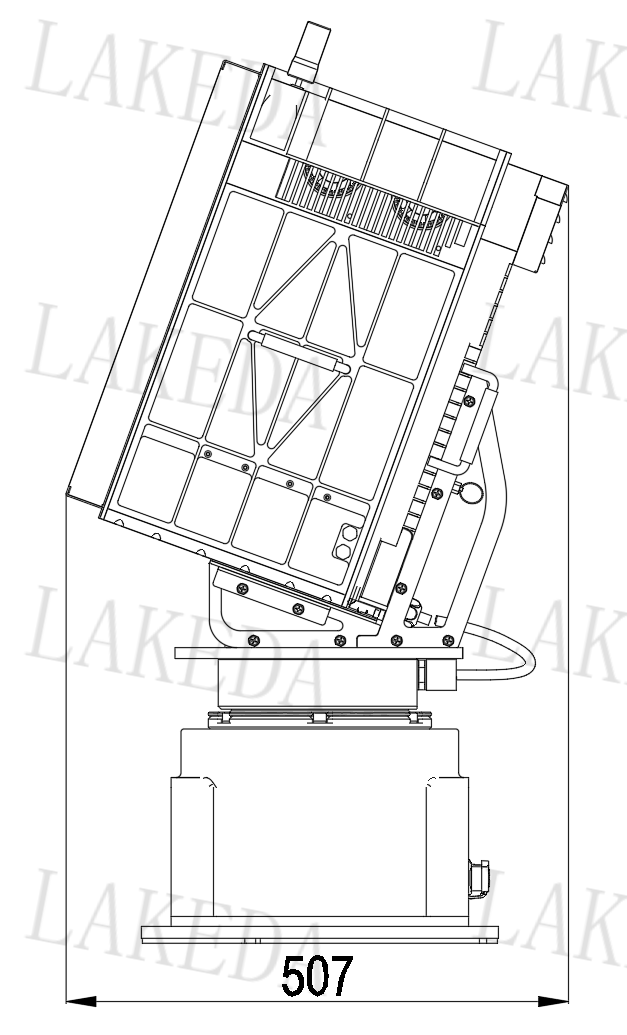
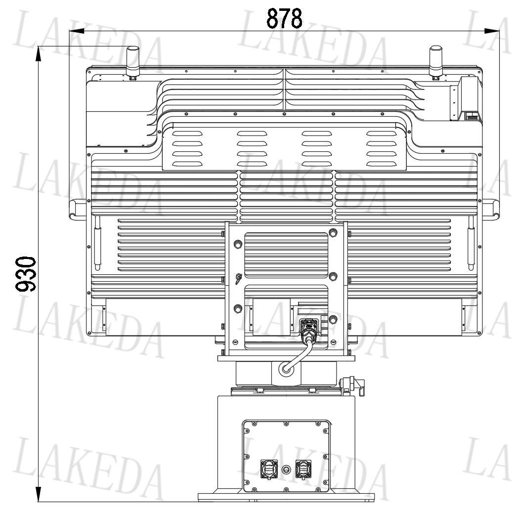
- Product Size
- Detection Range
-
- Commodity name: XW/SR226-5000SA Xuanwu Series - Low Altitude Security Radar
- Frequency Band: S-band
- Work system: Phased Array System (Three Coordinates) / Pulse Doppler
- Working frequency band: S-band
- Range: >=30km
- Effective detection power: ≥5.0km (RCS=0.01㎡); ≥25km (RCS=10㎡)
- Azimuth coverage: 360°
- Elevation coverage: ≥40°
- Detection speed: 1.8km/h~108km/h
- Azimuth accuracy: ≤ 0.8°
- Pitch accuracy: ≤ 1°
- Distance accuracy: ≤ 8m
- Data Rate: ≥0.2Hz
- Data Interface: RJ45/1-port 100Mbps Ethernet
- Power Input: ≤1500W (Power Consumption) AC200~AC240
- Working temperature: -40℃ to +55℃
- Weight: ≤100kg (complete machine)
Drone: ≥5.0km (RCS=0.01m²) ≥25km (RCS=10m²) Operating system: Phased array system (three coordinates) / Pulse Doppler Product composition: Consists of 1 radar array, 1 mechanical turntable, and 1 power adapter Application field: Mainly used for detection, alerting, and target indication of micro/small civilian drones in key areas such as prisons, exhibitions, and bases. It can accurately provide target azimuth, distance, altitude, speed, and other track information.
The XW/SR226-5000SA is an advanced micro/small civilian drone detection system, suitable for security protection in key areas such as prisons, exhibitions, and bases.
It consists of three main parts: radar array, mechanical turntable, and power adapter.
The radar array is the core of the system, responsible for detecting and tracking drones;
the mechanical turntable ensures flexible rotation of the radar, achieving all-around monitoring.
The power adapter provides a stable power supply to ensure continuous operation of the system.
The system can obtain real-time trajectory information of drones such as azimuth, distance, altitude, and speed, providing accurate data for alerting and target indication, effectively ensuring the security of key areas. It can accurately provide the target's azimuth, distance, altitude, and speed trajectory information.
-
Scanning Method
Electronic scanning is used in both horizontal and vertical directions, with fast scanning speed and wide coverage
Beam Control Capability
The beam direction can be adjusted on two axes, allowing rapid switching and formation of multiple independent beams, supporting multitasking in parallel
Target Processing Capability
Can simultaneously track hundreds of targets, strong anti-saturation attack capability, suitable for high-density, highly maneuverable target environments
Anti-Interference Performance
Through adaptive beamforming, sidelobe suppression, and other technologies, the anti-interference capability is significantly better than one-dimensional radar
Application Scenarios
Modern air defense systems: drone detection suitable for high-density, highly maneuverable target environments, with significant anti-interference capability
-
Working System
Phased Array System ( Azimuth Mechanical Scan + Two-dimensional Electronic Scan)
Operating Mode
Pulse Doppler
Operating Frequency Band
S Band
Instrument Range
≥ 30km
Maximum Detection Distance
≥ 5.0km ( RCS=0.01 ㎡); Detection Distance ≥ 25km ( RCS=10 ㎡)
Minimum Detection Distance
≤ 200m
Detection Range
Azimuth Coverage :360 °
Azimuth Electronic Scan Range ≥ 120 °
Elevation Coverage : ≥ 40 °
Elevation Electronic Scan Range ≥ 60 °
Detection Speed
1.0m/s ~ 100m/s
Measurement Accuracy
Range Accuracy : ≤ 8m
Azimuth Accuracy : ≤ 0.8 °
Elevation Accuracy : ≤ 1 °
Data Update Rate
≥ 0.2Hz (Antenna Rotation Speed: 12rpm )
Target Capacity
≥ 200 Batch
Data Interface
RJ45, UDP Protocol 100Mbps Ethernet
Power Supply and Consumption
Power Consumption: ≤ 1500W
Operating Voltage: AC 200 V -AC240 V
Operating Environment
Operating Temperature: -40 ℃~ +55 ℃;
Storage Temperature: -45 ℃~ +65 ℃;
Weight
≤ 100 kg
Note: The working environment test refers to the relevant parts of "GJB150A-2009 Military Equipment Laboratory Environmental Test Methods" for implementation.
-
-
Detection Range
Drone (RCS=0.01m²)
≥5.0km
Drone (RCS=10m²)
≥25.0km
Key words:
RELATED
Related Products
RELATED
Related Solutions

Solution
Thunderbolt All-in-One Machine


RELATED
Related Application Cases
Product Consulting

Address:8th Floor, Building 20, Guanggu New Power, East Lake High-Tech Development Zone, Wuhan, 430205.
Telephone:+86 13343423376 / +86-027-65520251
E-mail:lkd@radardo.com


SAF Coolest v1.3.1.2 设置面板 ADSSX-AONN-OSSVE-ZEZ
无数据提示
Sorry, the current column is being updated, please look forward to it!
You can view other columns or returnHome Page